Mapping Services
eMaps, or electronic maps are a form of geographic information system (GIS) which use digital cartography to present spatial data in different types of map formats. They offer various advantages over traditional paper maps

Mapping Services
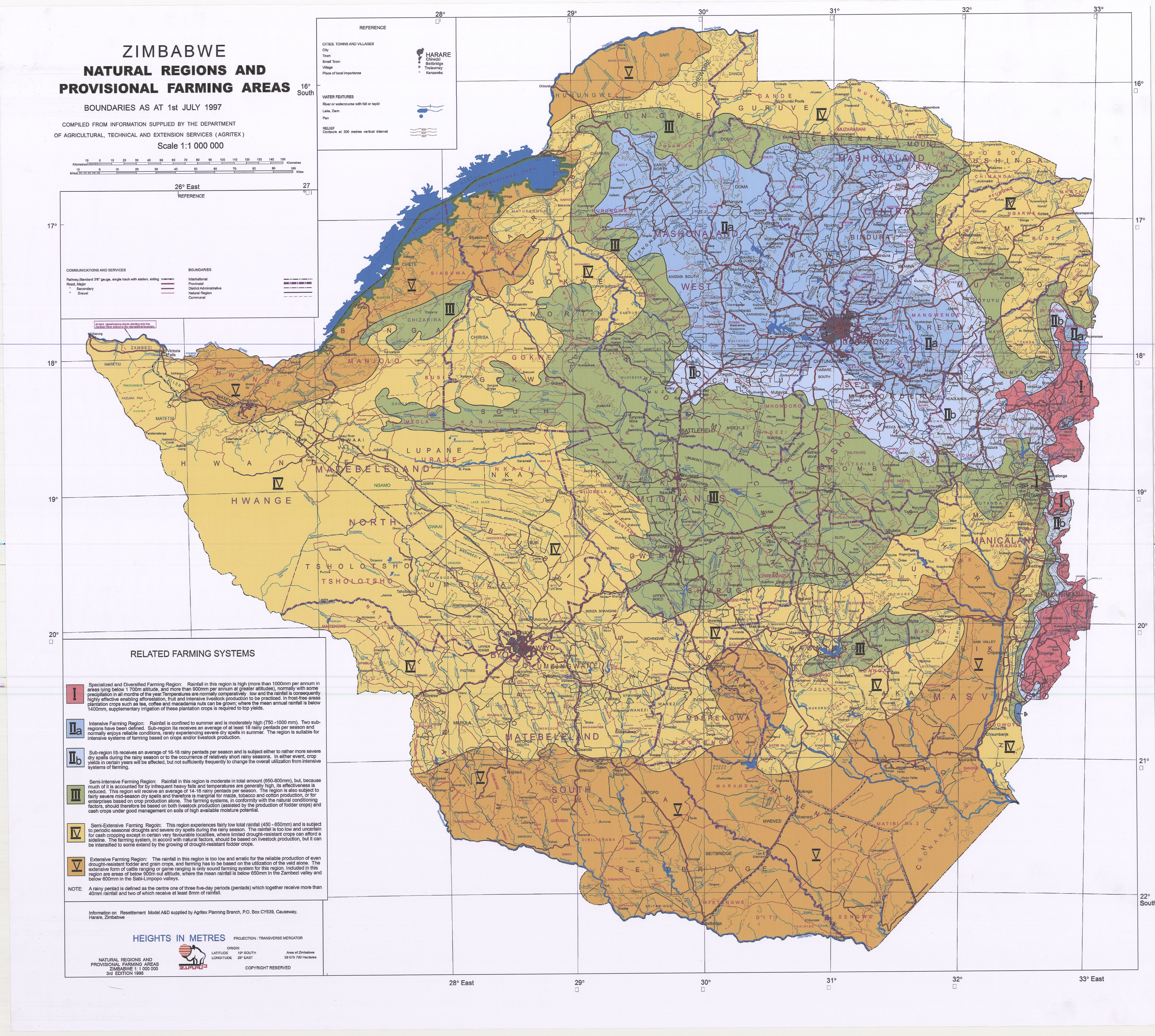
A map is a symbolic representation natural and man-made selected characteristic of a place, usually drawn on a flat surface.
Electronic maps are digital representations of geographic information and they can be used to display and edit a wide range of physical man-made and natural features on the ground.

Cartography is the art, science & technology of graphically representing a geographical area on a flat surface, produced to any selected scale

Use of maps
Navigation
Maps in navigation are used for the management and development of all national transport networks
Business
Maps are used to analyze market trends, study business locations, identify potential customers and marketing campaigns strategies
Planning and Decision Making
Maps are used by planners to identify areas that are suitable for different types of land use, such as agriculture, forestry, and urban development. Demographic data can also be overlaid on maps for sound and accurate planning.
Environmental & Disaster Management
Maps can be used to monitor and manage the environment. For example, maps can be used to track changes in land use, identify areas prone to natural disasters, and monitor the health of ecosystems. In the aftermath of a natural disaster, maps can be invaluable for rescue and relief efforts.
Politics & Military Operations
Today, maps are used in everything from election campaigns to demarcating electoral boundaries. Maps have also long been used for military purposes. Strategic planning, battlefield maps, intelligence gathering, and tactical planning are all critical components of military operations.
Geology
Geologists use maps to study the Earth’s surface and understand the processes that shape our planet. Maps can show the location of geological features, such as mountains, valleys, and rivers, and they can be used to study the formation of these features and the processes that shape the Earth’s surface.


eMaps Services
eMaps, or electronic maps are a form of geographic information system (GIS) which use digital cartography to present spatial data in different types of map formats. They offer various advantages over traditional paper maps, such as:
- The ability to view multiple layers and functions simultaneously.
- The capacity for real time updates if the underlying geographical data changes.
- Zoom capabilities that allow users to explore specific regions in detail while maintaining an overview of situational context.
- Dynamic navigation tools allowing interaction with other applications and services including address search functionality

eMaps products include:
Topo-Cadastral Maps
A topo-cadastral map is a map that graphically depicts both natural and man-made features on the ground with addition of cadastral property information such as the property name.
Aerial Drone Photos
Aerial drone photographs are acquired from the capture of still images and video by a remotely operated or unmannered aerial vehicle, also known as a drone. These photographs are used in photogrammetry in order to create 3D imagery and orthophotos amongst other products
Raw Data
Raw data refers to any data object that has been collected but has not yet been processed either manually or through computer software. It is gathered from various processes. Raw data can also be referred to as source data, primary data or atomic data
Thematic Maps
A thematic map is specialized map that is designed to visualize a particular subject or theme about a geographic area. These maps are used to depict physical, social, economic, political and even cultural aspects of a geographic area.
Map and Data Samples
Document Type
Description
Download Sample
Topo-cadastral Map
A document containing geometrical, numerical and verbal representations of a piece of land

Thematic Map
A plan which, representing the relative position and dimensions of one or more pieces of land
Drone Imagery
A dispensation certificate from local authority or physical planning to permit the survey

Raw Data
A permit to subdivide or consolidate any property granted in terms of section 41 of the Planning Act
Maps & Imageries
Price Range
$2.00 - $10.00
Frequently Asked Questions
-
 What is a map projection?
A map projection is the systemic drawing of a network of parallels and meridians on a flat surface to portray a part or whole of the earth's surface with a specific scale in accordance with a set of geometrical and mathematical principles in order to minimize distortions.
-
 What is a feature class?
It is a collection of geographic features with the same geometry type such as a point, line or polygon. It also contains the same attribute spatial reference. Feature classes can be stored in geodatabases, shapefiles and other data formats.
-
 What is metadata?
Metadata is data about data. It is information that describes the content, quality conditions, author purpose and other characteristics of data.
-
 What is a zip file?
It is a computer file whose contents have been compressed for storage or distribution. It usually carries the file extension .zip.
-
 What is an orthophoto?
An orthophoto is an aerial image that has been geometrically corrected (orthorectified) in such a way that the image is uniform from edge to edge. Orthophotos are corrected to remove distortions from the terrain, the camera lens and also the angle of camera tilt.
-
 Can I still visit the SG offices to buy hardcopy survey records?
Yes, anyone can still visit the SG's office for any services or products. Access is not limited to this portal only.
-
 What is a shapefile?
A shapefile is a vector data storage format used for storing the location, shape and the attributes of geographic features.